| Research Direction: Education 2008.9 - 2010.2 | Joint PhD Student (China Scholarship Council) |
| CSIRO Land & Water, Australia |
| Supervisor: Yun Chen, David Lemon | 2005.9 - 2010.7 | PhD Student |
| Department of Geography, East China Normal University |
| Supervisor: Jianping Wu | 2000.9 - 2005.7 | Bachelor Student |
| Institute of Software Engineering, East China Normal University (2002.9 - 2005.7) |
| Department of Geography, East China Normal University (2000.9 - 2002.7) |
Employment History 2021.7 – Present | Professor, Ph.D. Supervisor |
| School of Environmental and Geographical Sciences, Shanghai Normal University | 2013.7 – 2021.08 | Associate Professor, Master Student Supervisor |
| School of Environmental and Geographical Sciences, Shanghai Normal University | 2016.12-2017.12 | Visiting Scholar |
| Department of Geography, University of Connecticut Center for Environmental Sciences & Engineering, University of Connecticut | 2010.7- 2013.7 | Lecturer |
| Department of Geography, Shanghai Normal University |
Courses Taught Secondary Development of GIS | Thematic Mapping | Spatial Data Acquisition and Organization | GPS Technology and Application |
Research Interests Artificial intelligence-based spatial modeling (such as agent-based system, ant colony optimization, particle swarm optimization, and cellular automata)
| | | |
Publications | YU Jia, ZHANG Chuanrong, WEN Jiahong, LI Weidong, LIU Rui, XU Hui, 2018, Integrating Multi-agent Evacuation Simulation and Multi-criteria Evaluation for Spatial Allocation of Urban Emergency Shelters, International Journal of Geographical Information Science. (SCI, SSCI, published online) 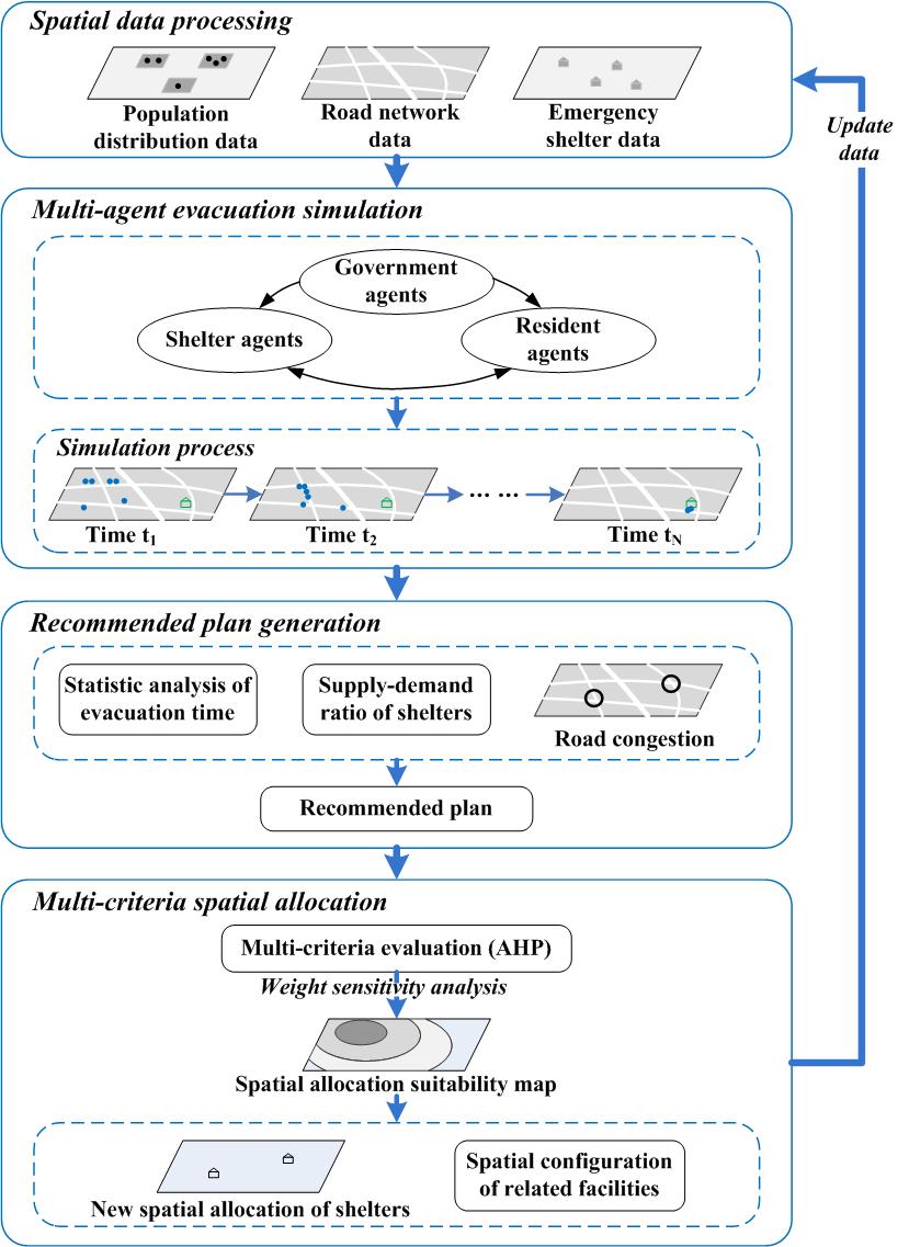
Framework for spatial allocation of urban emergency shelters | | YU Jia, WEN Jiahong, CHEN Yun, LIAO Banggu, DU Shiqiang, 2017, Spatial configuration of urban shelters based on simulation using emergency evacuation agent-based model: A case study in Jing'an District, Shanghai, Acta Geographica Sinica. 72(8), 1347-1364. (EI, CSSCI, CSCD, in Chinese) 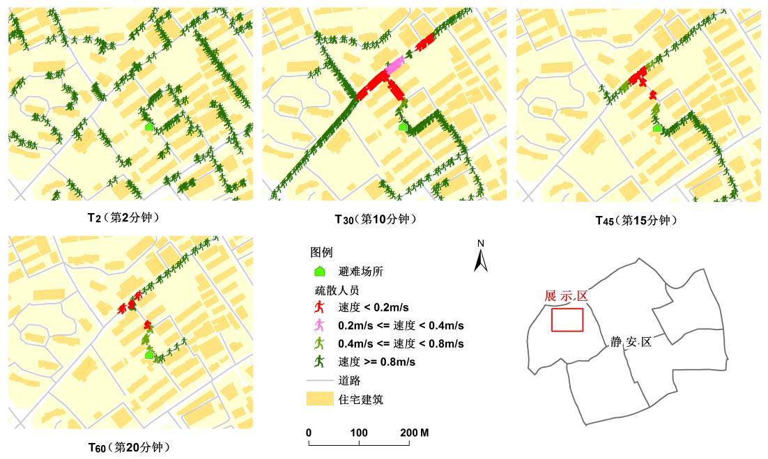
Agent-based evacuation simulation | | YU Jia, WEN Jiahong, 2016, Multi-criteria Satisfaction Assessment of Spatial Distribution of Urban Shelters based on High-precision Population Estimation, International Journal of Disaster Risk Science.7(4), 413-429. (SCI, 2016 IF: 1.222) 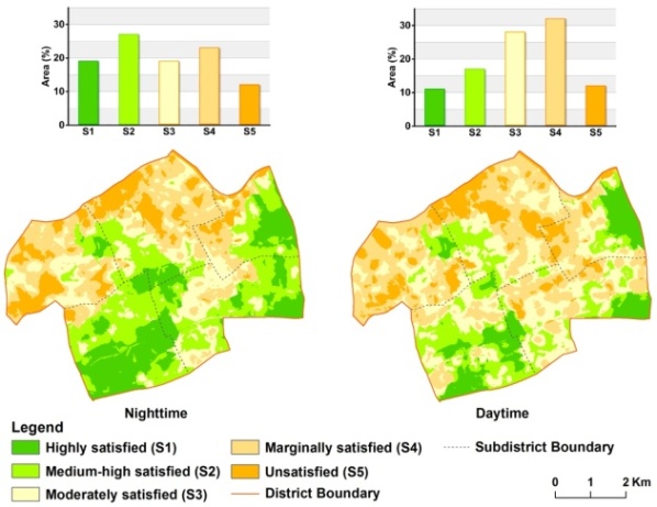
Satisfaction assessment of the spatial distribution of emergency shelters for daytime and nighttime | | CHEN Yun,YU Jia(Corresponding Author), KHAN Shahbaz, 2013, The spatial framework for weight sensitivity analysis in AHP-based multi-criteria decision making. Environmental Modelling and Software. 48, 129-140. (SCI, 2016 IF: 4.404)  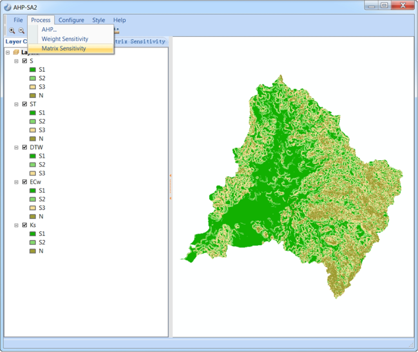
Developed AHP-SA2 Tool
| | YU Jia, WEN Jiahong, JIANG Yong, 2015, Agent-based Evacuation Simulation for Spatial Allocation Assessment of Urban Shelters , 2015 International Conference on Intelligent Earth Observing and Applications (2015 IEOAs). Proc. of SPIE Vol. 9808, 98081N, 1-10, DOI: 10.1117/12.2209277. (EI) 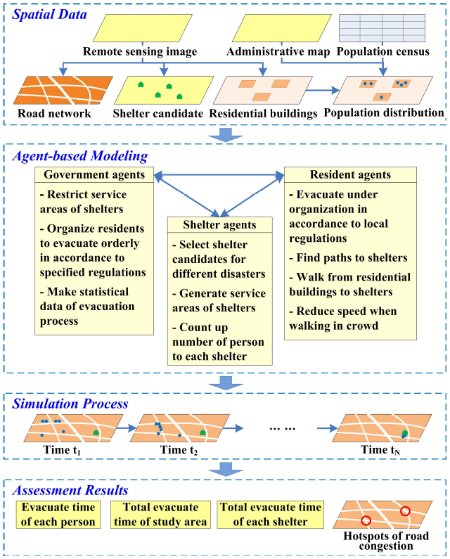
Spatial allocation assessment framework of urban shelters
| | YU Jia, CHEN Yun, WU Jianping, KHAN Shahbaz, 2011, Cellular Automata Based Spatial Multi-criteria Land Suitability Simulation for Irrigated Agriculture. International Journal of Geographical Information Science. 25(1), 131-148. (SCI, 2016 IF: 2.502)
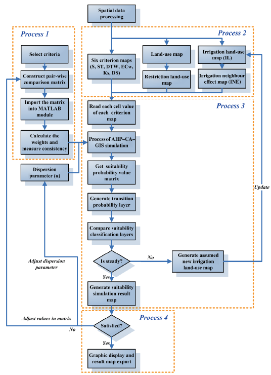 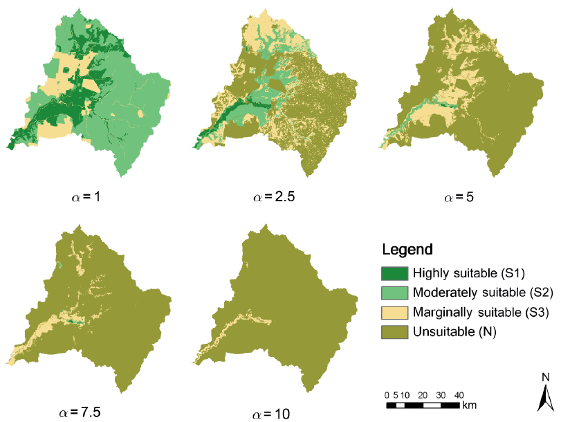
Cellular automata based modeling and potential land suitability simulation
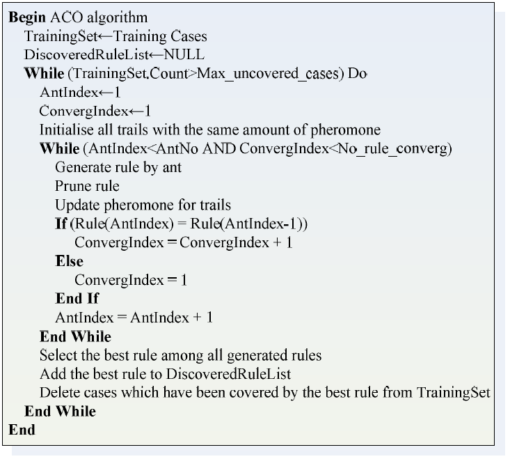
| | YU Jia, CHEN Yun, WU Jianping, 2011, Modeling and Implementation of Classification Rule Discovery by Ant Colony Optimisation for Spatial Land-use Suitability Assessment. Computers, Environment and Urban Systems. 35(4), 308-319. (SSCI, EI, 2016 IF: 2.659)
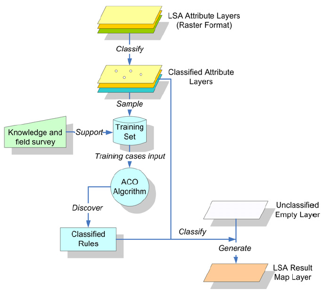 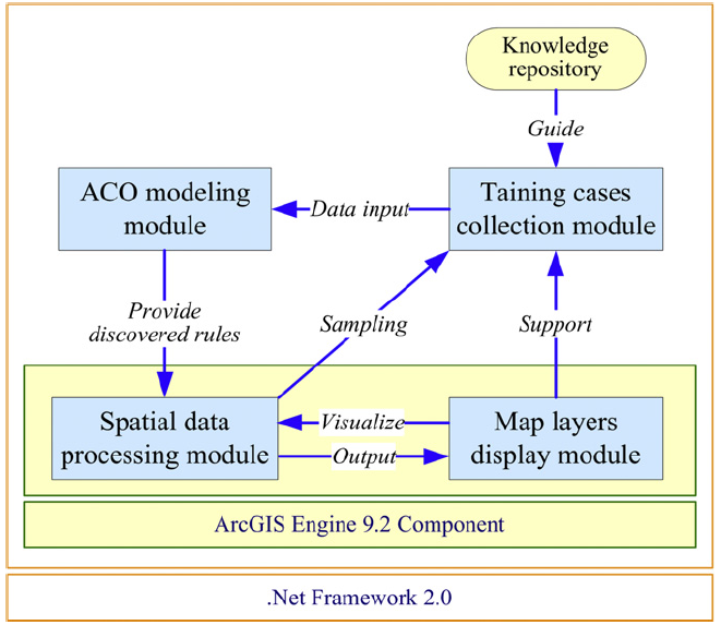
Architecture and function modules of developed ACO-LSA tool
| | YU Jia, CHEN Yun, WU Jianping, LIU Rui, XU Hui, YAO Dongjing, FU Jing, 2014, Particle Swarm Optimization based Spatial Location Allocation of Urban Parks - A Case Study in Baoshan District, Shanghai, China. Agro-Geoinfomatics. (EI, IEEE) 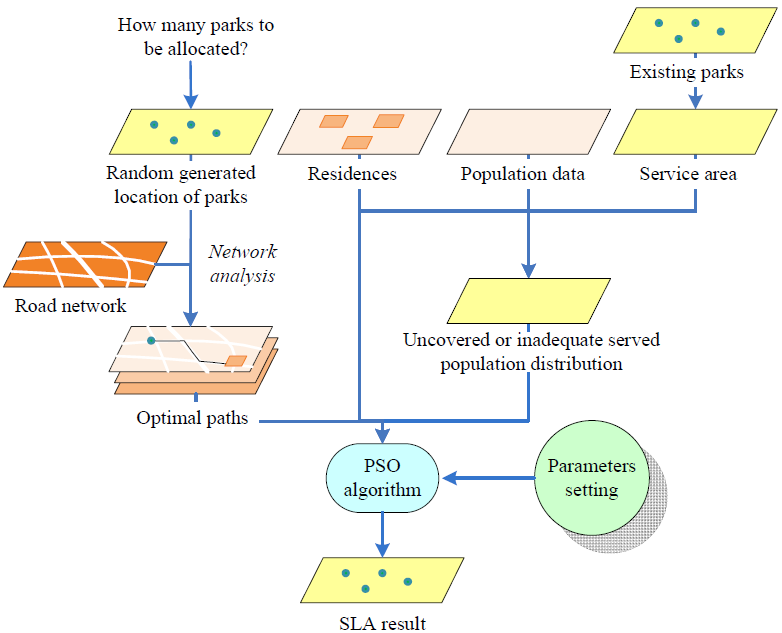 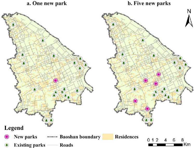
Architecture of particle swarm optimization based location allocation and analysis results for parks
| | CHEN Yun, YU Jia, KHAN Shahbaz, 2010, Spatial Sensitivity Analysis of Multi-Criteria Weights in GIS-based Land Suitability Evaluation. Environmental Modelling and Software. 25(12), 1582-1591. (SCI, 2016 IF: 4.404, ESI top 1%) 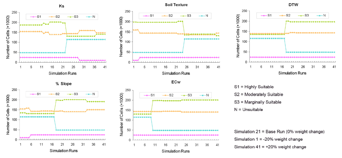
Spatial Sensitivity Analysis |
Other Academic Papers | LIU Rui,CHEN Yun,WU Jianping, GAO Lei, BARRETT Damian, XU Tingbao,LI Xiaojuan, LI Linyi, HUANG Chang, and YU Jia, 2017, Integrating Entropy-Based Naive Bayes and GIS for SpatialEvaluation of Flood Hazard, Risk Analysis. 37(4), 756-773. DOI: 10.1111/risa.12698. (SCI, 2016 IF: 2.518) | | LIU Rui, CHEN Yun, WU Jianping, XU Tingbao, LI Linyi, YU Jia, HUANG Chang, SHI Kaifang, 2016, Evaluating Likelihood Distribution of Flood Risk Integrating Bayesian Networks and GIS - A Case Study in Bowen Basin, Australia.Agro-Geoinfomatics. (EI, IEEE) | | LIU Rui, CHEN Yun, WU Jianping, GAO Lei, BARRETT Damian, XU Tingbao,LI Linyi, HUANG Chang, YU Jia,2016, Assessing spatial likelihood of flooding hazard using naive Bayesand GIS: a case study in Bowen Basin, Australia, Stochastic Environmental Research and Risk Assessment. 30(6), 1575-1590. (SCI, 2016 IF: 2.629) | | YU Jia, WEN Jiahong, JIANG Yong, DU Shaoni, LI Weijiang, LI Xiande, GAO Jun, 2015, Evaluation of Spatial Configuration and Cross-regional Sharing of Urban Shelters, 2015 International Conference on Computer Sciences and Applications (CSA 2015). 360-365, DOI: 10.1109/CSA.2015.13(EI)
 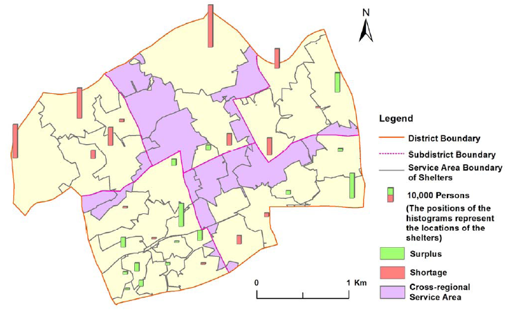
Population capacity and cross-regional sharing of shelters
| | YU Jia, CHEN Yun,LIU Jingyi, WU Jianping, FU Jing, XU Hui, 2014, One-At-A-Time based Weight Sensitivity Analysis in Spatial Multi-Criteria Decision Making, Resources Science. 36(9),1870-1879.(CSCD, SSCI, in Chinese) | | HUANG Chang,CHEN Yun, WU Jianping, CHEN Zuoqi, LI Linyi, LIU Rui, YU Jia,2014, Integration of remotely sensed inundation extent and high-precision topographic data for mapping inundation depth. Agro-Geoinfomatics. (EI, IEEE) | | XU Hui, HUANG Xianjin, ZHONG Taiyang, CHEN Zhigang, YU Jia, 2014, Chinese land policies and farmers’ adoption of organic fertilizerfor saline soils. Land Use Policy. 38, 541-549. (SSCI, 2016 IF: 3.089) | | LIU Jingyi, CAI Yongli, YU Jia (Corresponding Author), WANG Yun, 2013, Optimization of Land Use Arrangement in North Jiaxing Based on CLUE-S and Grey Linear Programming, Journal of Ecology and Rural Environment. 4, 529-536. (CSCD, CSSCI Extended, in Chinese) | | YU Jia, CHEN Yun, WU Jianping, HUANG Chang, 2012, Ant Colony Optimisation based Land Use Suitability Classification. Agro-Geoinfomatics. (EI, IEEE)
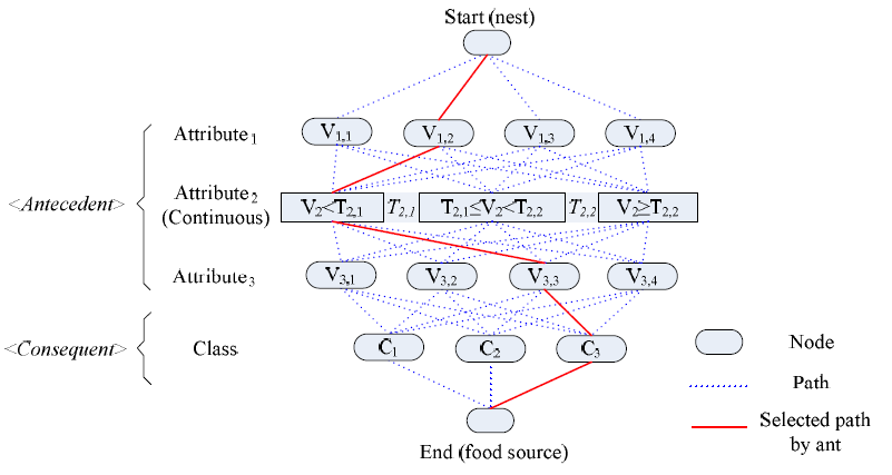 
Continuous ACO algorithm
| | HUANG Chang,CHEN Yun, WU Jianping, YU Jia,2012, Detecting Floodplain Inundation Frequency Using MODIS Time-series Imagery. Agro-Geoinfomatics. (EI, IEEE) | | YU Jia, CHEN Yun, 2011, Comparison of AHP and ACO-LSA in Land Use Suitability Evaluation. ICISE 2011. 2449-2452. | | SHAN Fuzheng, YU Jia, ZHAO Jun, QIAN Guangren, 2011, Land Use Change in the Suburb Area and Its Impacts on Carbon Emissions in the Process of Industrialization: A Case Studyof Zhangjiang Hi-Tech Park, Shanghai, Resources Science. 33(8), 1600-1607. (CSCD, CSSCI, in Chinese) | | YU Jia, WU Jianping, GAN Jiayuan, 2010, Study on Interaction Design of GIS Application Software, Computer Applications and Software. 27(1), 165-195. (CSCD Extended, in Chinese) | | YU Jia, CHEN Yun, WU Jianping, 2009, Cellular automata and GIS based landuse suitability simulation for irrigated agriculture, In: F. Cook, & L. Neumann (Eds.), 18th World IMACS / MODSIM Congress, Cairns, Australia (pp. 3584-3590). | | YAN Yongbin, YU Jia (Corresponding Author), WU Jianping, MA Suyan, 2009, Design and Implementation of a Mobile GIS for Field Data Collection, Computer Science and Information Engineering,2009 WRI World Congress, Los Angeles, CA, USA (pp. 235-241). (EI, IEEE) 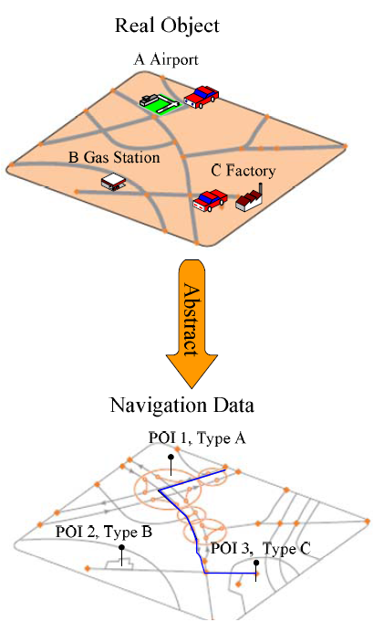 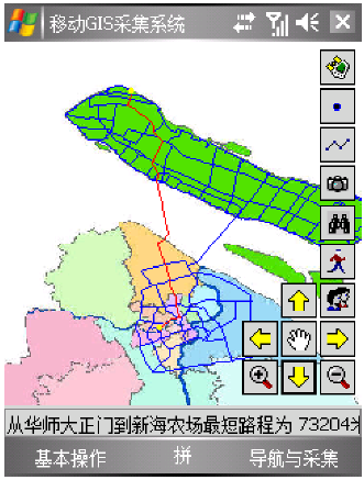
| | CHEN Yun,YU Jia, KHAN Shahbaz, XEVI Emannel, 2009, A GIS-Based Sensitivity Analysis of Multi-Criteria Weights, In: S. Khan & R. Argent (Eds.),18th World IMACS / MODSIM Congress, Cairns, Australia (pp. 3137-3143).
| | YU Jia, GAN Jiayuan,WU Jianping, YAO Shenjun, 2008, An Algorithm Study on Intelligent Traffic Lights Adjustment based on Decision Tree, Science of Surveying and Mapping. 33(6), 23-25. (CSCD, in Chinese) | | YU Jia, WU Jianping, 2008, The Method and Practice of Establishing Geodatabase Using UML Model, Geomatics & Spatial Information Technology. 31(1), 6-11. (in Chinese) | | YU Jia, WU Jianping, YI Min, 2007, Research and Implementation of Road Monitoring GIS System. In :Geospatial Information Technology and Applications edited by Peng Gong, Yongxue Liu, Proceedings of SPIE. 6754, DOI: 10.1117/12.764616.(EI)
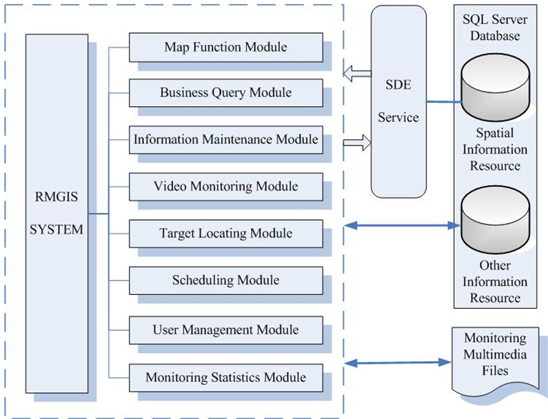 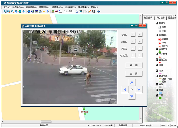
Road Monitoring GIS System
| | YI Min, WU Jianping, YAO Shenjun, YU Jia, 2007, Application of GIS in Environmental Monitoring Data Management and Analysis, Environmental Science and Management. 32(12), 148-153. (in Chinese) | | YAO Shenjun, WU Jianping, YI Min, YU Jia, 2007, Application of GIS on Environmental Impact Assessment, Environmental Science Survey. 26(6), 77-80. (in Chinese) |
Books
| LIU Jingyi, YU Jia, WANG Yun, 2015. 5, Regional Sustainable Land Use Optimization and Planning Support, Chinese Forestry Press. |
Research Projects 2018.4 - 2020.4 | "Climbing" Program of Tourism College, Shanghai Normal University / Shanghai Institute of Tourism "Intelligent location-allocation of emergency shelters and evacuation planning in urban residential districts" | 2013.1 - 2015.12 | Project of National Natural Science Foundation of China (41201548) "Spatial Location-Allocation of Urban Shelters Based on Agent of Emergency Evacuation" | 2012.1-2015.1 | Innovation Program of Shanghai Municipal Education Commission (12YZ086) "Particle Swarm Optimization based location allocation of urban recreational spaces" | 2014.6 -2015.9 | Project of Research Center for San-En-Nanshin Regional Collaboration, Aichi University Joint Research Center for Cross-border Territories Policy, Japan "Spatial configuration Evaluation and Cross-border Sharing of Shelters" | 2011.11 – 2013.11 | Open Research Funding Program of Key Laboratory of Geographic Information Science, Ministry of Education, East China Normal University, Shanghai (KLGIS2011A05) "Weight Sensitivity Analysis in Spatial Multi-criteria Decision Making" | 2012.1 – 2013.12 | Project of Science and Engineering of Shanghai Normal University (SK201251) "Impact of Rail Traffic Construction on Accessibility of Tourist Attractions in Shanghai" | 2012.3 – 2015.3 | Funding Plan of Shanghai Municipal Education Commission for the Development of Young Teachers in Colleges and Universities (shsf019) "Gravity Model based Accessibility Analysis of Urban Public Recreational Spaces" |
2017.1-2019.12 | Project of National Natural Science Foundation of China (71603168) | 2015.1 –2017.12 | Project of National Natural Science Foundation of China (41401603) "Modelling the impact of land use pattern on flood risk under multiple rainfall scenarios-a case study of Longhua River basin in Shenzhen, China" | 2015.1-2015.12 | Key Project of Shanghai Institute of Tourism "Operation and Spatial Distribution of Exhibition Center in Yangtze River Delta Region" | 2013.7 – 2016.6 | Project of National Social Science Foundation of China (13CGL083) | 2014.1 – 2015.12 | Youth Experts Plan of China National Tourism Administration (TYETP201348) | 2014.1 – 2014.12 | 085 Project of Shanghai Normal University | 2012.1 – 2012.12 | Key Project of Shanghai Normal University (DZL801) | 2011.10 – 2012.3 | Smart Tourism Planning of Yangzhou | 2011.2 – 2011.8 | Intelligent Tourism Integrated Information Platform of Daqing City |
Awards | 2015 The Third National GIS Teaching Contest of Young Teachers of Chinese Univeristies, Third Prize | | 2015 ResearchAward of Shanghai Normal University | | 2013-2014 Outstanding Award of Shanghai Normal University | | 2013.8 Certification of MapGIS Lecturer | | 2013 The 11th Outstanding Young Teacher of Shanghai Normal University | | 2013 ResearchAward of Shanghai Normal University | | 2012 Special Personal Award of Scientific Work of Tourism Collage, Shanghai Normal University | | 2012 Jinjiang Scientific Research Awards of Tourism Collage, Shanghai Normal University | | 2012 ResearchAward of Shanghai Normal University | | 2008.9 - 2010.2 Scholarship of China Scholarship Council | | 2010 ResearchAward of East China Normal University | | 2010 Application Developer Contest of ESRI, Third Prize |
Membership | Chinese Professional in Geographic Information Systems | | Agro-Geoinfomatics | | Infrared and Remote Sensing Committe of Shanghai |
Reviewer and Social Work Reviewer | Environmental Modelling and Software | | International Journal of Geographical Information Science | | Computers, Environment and Urban Systems | | Journal of Environmental Informatics | | Transportation Research Part D: Transport and Environment | | Journal of Environmental Planning and Management | | Geocarto International | | Arid Land Research and Management | | Solid Earth | | Frontiers of Earth Science | | Arabian Journal of Geosciences | | Iranian Journal of Fuzzy Systems | | Sustainable Development | | Reviewer of National Natural Science Foundation of China |
Social Work
| Evaluation Expert of Government Procurement of Shanghai |
| AHP-SA AHP-SA is a software tool which can analyze weight sensitivity caused by both direct and indirect weight changes using the one-at-a-time (OAT) technique with the Analytical Hierarchy Process (AHP) in the ArcGIS environment. It permits a range of user defined simulations to be performed to quantitatively evaluate model dynamic changes, measures the stability of results with respect to the variation of different parameter weights, and displays spatial change dynamics. Please find the tool at the following URL:  AHP-SA2 Tool (ArcGIS10.2).rar AHP-SA2 Tool (ArcGIS10.2).rar
AHP-SA2 Tool (ArcGIS10.8).rar | | TGRAM TGRAM is a software tool with graphical interfaces for estimating experimental transiograms from point sample data (in shapefile format) and performing transiogram joint model-fitting to obtain a whole set of transiogram models for simulation of categorical fields. Please find the tool at the following URL: http://gis.geog.uconn.edu/weidong/MCG/MCG_Software.htm
|
| Yaqin Li, Jia Yu*, Yuanfan Zheng*, Quanyi Shen, Yang Zhou, Hangxing Wu, Min Zhang, Jiahong Wen, Supply-Demand Allocation and Distribution Path Optimization of Emergency Food Materials under Flood Scenarios: A Case Study in Fengxian District, Shanghai, China, International Journal of Disaster Risk Science. (Accepted) Please find the Appendix of this paper at the following URL:  Appendix-Supply-Demand Allocation and Distribution Path Planning of Emergency Food Materials under Flood Scenarios.pdf Appendix-Supply-Demand Allocation and Distribution Path Planning of Emergency Food Materials under Flood Scenarios.pdf
|
|